
 News
News Published Walks
- Current Events
- Event History
- About us
 Path Work / Issues
- Links & Supporters
- Contact
- Documents
Path Work
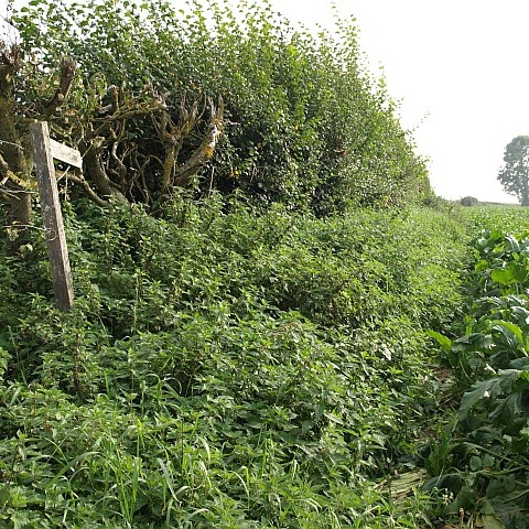
Many of our rights of way are natural unsurfaced paths through grass, maybe between hedges. Unfortunately, this ‘intimacy’ with nature can become unwelcome when vigorous growth of nettles, brambles and hedges - especially from May and through the summer - can start to block the paths. Regular walking of the paths identifies the potential problems and in itself helps keep them clear. HERE is a sample of the volunteer work keeping our paths open.
Path Issues
On this page, we bring information about significant issues affecting the rights-of-way in Dereham. We’ll try to keep it up to date, but we can’t be everywhere every day, so if you come across an issue, please let us know by emailing ken-hawkins@tiscali.co.uk.
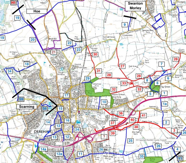
A map showing the locations of all our paths is HERE (PDF, opens in new tab). You can also see these paths on Norfolk County Council’s interactive map at maps.norfolk.gov.uk/highways (opens in a new tab)
Last updated: 24 April 2026
Footpath 2 (Updated 22 April)
The northern part of this path, leading from Mattishall Road, has been reported
many times as the crop is sown right up to the field edge. It is possible to
walk through crop on this section, but it’s oil seed rape, so your legs/trousers
will likely end up pretty yellow. The remainder of the path is well marked and
easy to walk.
Restricted byway 3 (Updated 24 April)
A path has been made through the low crop - not the straight line it should be,
but does go from end to end. This is suitable for walkers, though not for the
cyclists, horse riders or carriage drivers legally entitled to use it. Where the
path joins Restricted Byway 38 at the north end, there is a short but steep
slope which requires change: this has been reported.
Footpath 9 (No change at 22 February)
Almost alone among the rights of way in Dereham, we do not recommend attempted
use of this path, because (1) it is accessed at the south from Swanton Road,
which is a bendy road, not subject to a speed limit and without a footway, (2)
it is so overgrown as to be impenetrable and (3) legal rights of usage end at
the parish boundary long before the path reaches Hall Road in Hoe and Worthing
Parish.
Footpath 10 (22 March)
We understand that Norfolk County Council plans to close this path from 1 to
28 April (and possibly longer) to undertake resurfacing work. No diversion is
being proposed, but there are two links from Norwich Road to The Neatherd,
either via Crown Road to the west or through the Little Neatherd to the east.
Footpath 14 (Updated 22 April)
As promised by NCC, the legal course of this path, immediately adjacent to the
school fence from its junction with Footpath 13 to Sardis Way, has been cleared
and is easily walked. A litter pick early in April has made this path more
presentable. We also understand that NCC plans to grind the tree stumps in the
path this winter; until then, walk with care.
Footpath 14a (Updated 22 February)
The boardwalk on this path was recently renewed and a new section of boardwalk
adjoining Stone Road put in place. Unfortunately, the renewed boardwalk merely
replaced the previous boardwalk and did not extend across the few metres at the
southern end which regularly became a quagmire after wet weather. It is
currently very muddy again though can be walked with care (and good boots!).
Footpath 25 (Updated 24 April)
After the recent dry weather, the southern end of this path, where it meets
Footpath 26, is fully walkable.
Footpath 26 (Dumpling Green) (Updated 24 April)
Sections of this path are subject to considerable muddiness and water collecting
in deep ruts. The problem arises partly from poor drainage and partly from the
private (though legal) use of motorised vehicles. Town and County Councillors
have discussed the problem with Norfolk County Council officials and an approach
proposed, though it is early days yet. But after the recent dry weather, there
are no problems at present.
Restricted byway 28 (Awaiting checking as at 22 February)
The eastern end of this, after Footpath 7 and the farm buildings, is prone to
substantial vegetation growth, though is currently walkable (but not usable by
carriage drivers). Note that there is no footway on Mowles Road at the eastern
end.
Footpath 34 (Awaiting checking as at 22 February)
The northern section of the stream side part of the path is prone to significant
muddiness after wet weather, though usually remains walkable with care.
Footpath 35 (Updated 22 February)
This path leads from Footpath 26 to Badley Moor (open to the public). Parts of
the track are quite wet and muddy, but walkable with a little care.
Restricted byway 36 (Cherry Lane) (Updated 22 April)
The potholes which appeared after last year’s resurfacing of the section from
Norwich Road to the Windmill have been treated and, for now at least, make
walking and cycling more straightforward again.